
≈20 M
Schistosomiasis
A parasitic infection from contaminated water that affects up to 20 million people across the Nile Basin.

A modern vision draped in ancient gold — a bold engineering & ecological blueprint to restore, purify and reawaken the longest river on Earth.
The sacred river that birthed civilization is now choking under industrial effluents, untreated sewage, agricultural chemicals and rivers of plastic.
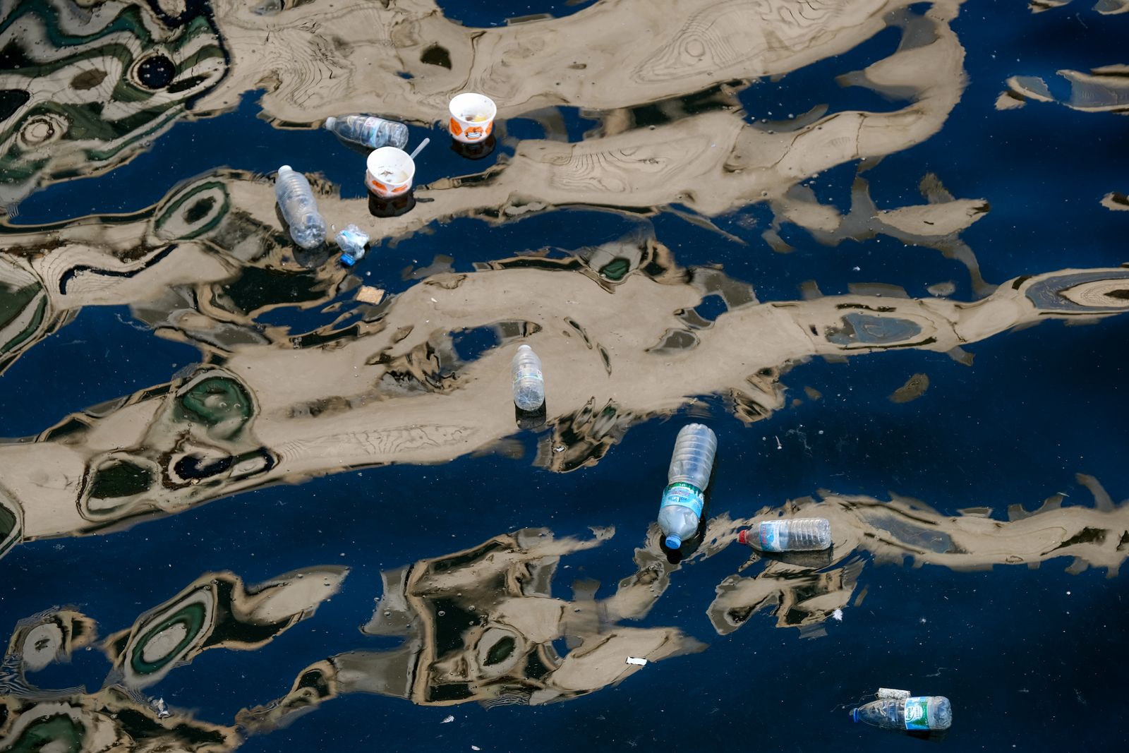
~84,000 tons
of plastic delivered by the Nile to the Mediterranean Sea every year.
Share of total pollutant load reaching the river (estimated).
Untreated factory effluents containing heavy metals, dyes and chemicals.
Over 5 billion m³ of untreated wastewater enters the Nile each year.
Pesticides and nitrogen fertilizers driving algal blooms.
The Nile carries an estimated 84,000 tons of plastic to the sea yearly.
Beneath the river's gentle current flow waterborne pathogens that strike at children, farmers and fishers along the entire basin.
A parasitic infection from contaminated water that affects up to 20 million people across the Nile Basin.
Bacterial infection causing severe dehydration; recurrent outbreaks in Sudan, South Sudan and Ethiopia.
Salmonella Typhi spreads through faecally contaminated Nile water and untreated drinking sources.
Viral liver infections endemic to riverside communities with limited sanitation.
A leading cause of child mortality in the Nile basin, driven by polluted water.
Lead, mercury and cadmium bioaccumulate in fish, harming nervous and renal systems.
The scale of the world's longest river is staggering — and so is the responsibility of those who live upon its gift.
Total Length
0 km
Longest river on Earth — surpassing the Amazon by 250 km
Drainage Basin
0.00M km²
10% of Africa’s surface across 11 nations
Annual Discharge
0 km³
Mean flow volume at Aswan (≈ 84 trillion litres/yr)
People Dependent
0M+
Lives sustained — 4% of the world population
Avg. Flow Rate
0 m³/s
Equivalent to filling 1 200 Olympic pools daily
Years of Civilization
0+
Of continuous human history along its banks
Fish Species
0+
From Nile perch (200 kg) to lungfish
Bird Species
0+
Resident + migratory — a vital flyway
Aquatic Plants
0+
Papyrus, lotus, water hyacinth, reeds
Sediment to Delta
0 Mt/yr
Fertile silt feeding 24 000 km² of farmland
Major Tributaries
0
Blue Nile, White Nile, Atbara and more
Delta Surface
0 km²
One of the world’s most fertile regions
From the highlands of Ethiopia to the delta of Egypt, more than 300 million people braid their lives into the river’s water. It feeds fields, lights cities, carries trade and inspires pilgrimage.

85%
of usage
More than 95% of Egypt’s freshwater for irrigation comes from the Nile, sustaining cotton, wheat, rice and sugarcane.
7%
of usage
Primary tap-water source for cities from Khartoum to Cairo — around 250 million daily users.
2%
of usage
Tilapia, Nile perch and catfish provide protein and livelihoods for over 2 million households.
3%
of usage
Aswan High Dam and Grand Ethiopian Renaissance Dam together supply over 16 GW of clean energy.
1%
of usage
Feluccas and cargo barges still move goods along ancient Nile routes between cities.
2%
of usage
Nile cruises and riverside heritage sites attract over 13 million visitors a year.
The Nile is the world’s greatest freshwater ark — home to 200 fish, 350 birds, 800 aquatic plants and 40 mammals. Before any drop is evaporated, we must shelter every form of life that calls it home. Restoration without extinction is the founding ethic of this project.
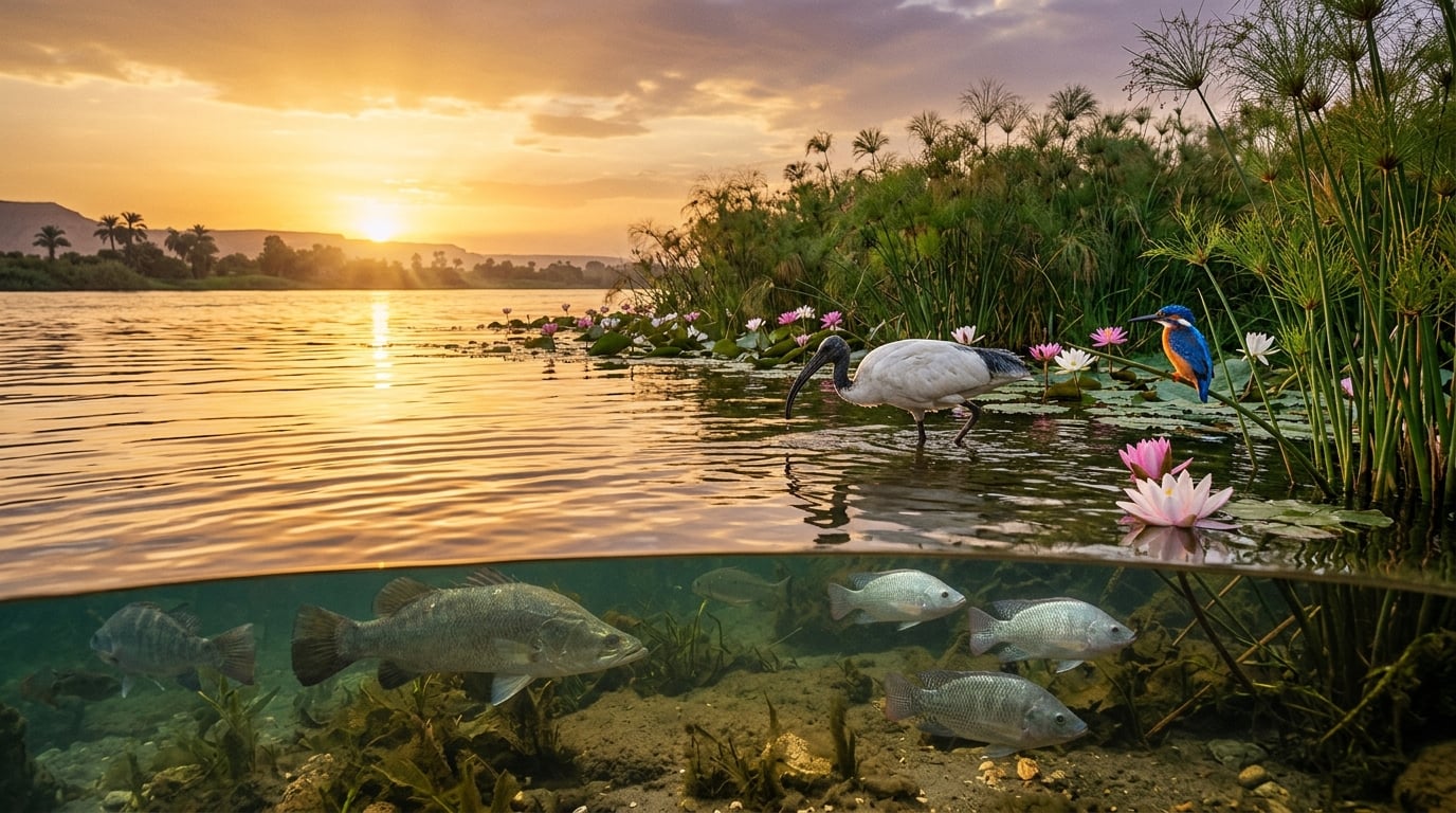
A Cathedral of Species
An entire flyway, food-web and gene-bank flowing through one river.
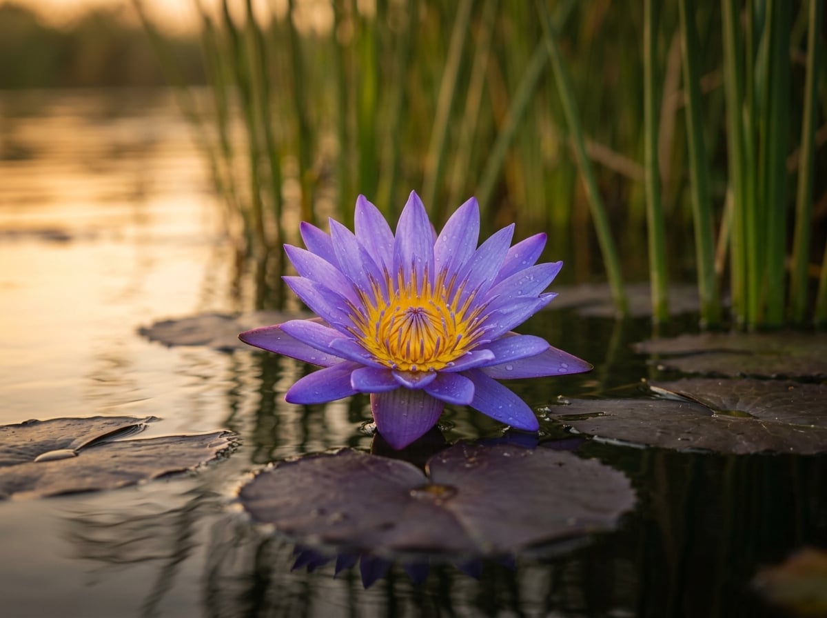
Nymphaea caerulea
The blue lotus, sacred to Ra — every dawn it reopens with the sun.
Section 1 · Inventory
200+ species
350+ species
800+ species
60+ species
40+ species
2 000+ species
Section 2 · Protocol
Six-month ecological census prior to any evaporation: DNA barcoding of every fish & invertebrate, drone counts of bird colonies, satellite tracking of mammal pods.
Pontoon-mounted refugia (50 000 m³ capacity each) deployed along the riverbanks. Pumped clean water from upstream maintains pH, dissolved oxygen and temperature for indigenous fauna.
Only 200–500 m segments are processed at any one time. Fish, reptiles and mammals are gently herded into refugia using ultrasonic guidance and shallow gradient channels.
All aquatic plant seeds and rhizomes (papyrus, lotus, reeds) are preserved in cryogenic vaults & living-collection greenhouses at Aswan & Khartoum botanical stations.
After purification, every species is reintroduced in reverse migratory order: bottom-up from invertebrates and plants, through fish, to apex mammals — restoring the food web from its base.
< 1 %
biodiversity loss target
Industry standard for major hydro-engineering is 8–15 %.
50 000 m³
per refugium
20 such pontoons can house an entire river segment’s fauna.
6 mo
pre-survey window
Full eDNA + satellite mapping before any evaporation begins.
200+
fish species preserved
Plus 350 birds, 800 plants, 40 mammals, 60 reptiles, 2 000 inverts.
« Restoration without extinction » — the project’s ethical charter. References: IUCN Red List 2024, FishBase, AvianBase, Egyptian Environmental Affairs Agency.
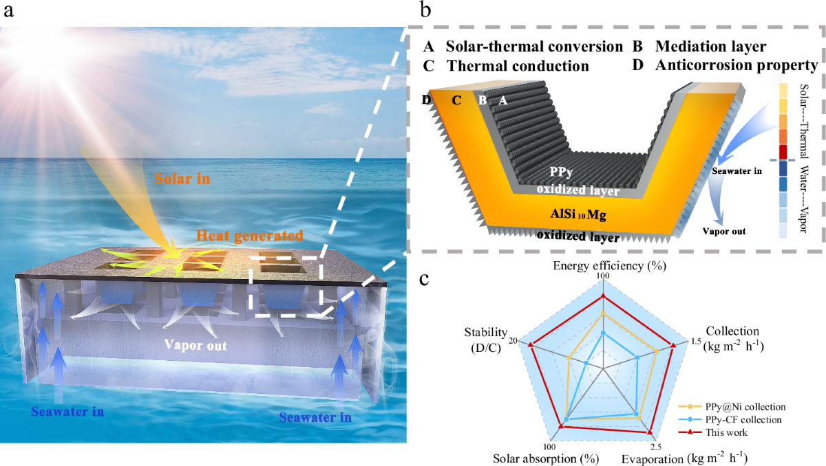
Giant TV-screen lenses concentrate sunlight onto sections of the Nile, forcing evaporation. Steam is captured, condensed and stored in adjacent basins where fish are farmed. The fish’s nutrient-rich water is cycled back out to fertilize riverside vegetation — a self-sustaining temple of life.
The Egyptian sun — the very Ra worshipped along the river — is harvested over enormous areas.
Massive flat lens arrays focus sunlight precisely onto sections of the polluted Nile.
Water flashes into vapor, leaving pollutants behind. Pure steam is funneled into closed condensers.
Cleaned, condensed water collects in adjacent stone basins lined like ancient cisterns.
Tilapia and catfish populate the basins, feeding communities and generating fertilizer.
A water-exchange system cycles fish-waste-rich water out to fertilize riverside crops naturally.
+92%
water purity after condensation
≈ 4 GW
thermal energy harvested per km of lens array
Zero
chemical inputs — only sunlight and biology
Inspired by mass-produced flat-panel TV screen optics, giant thin-film Fresnel lenses made of PMMA acrylic can concentrate the Egyptian sun over 1,000 times — enough to force-evaporate polluted Nile water in seconds and condense it into clean, drinkable water.
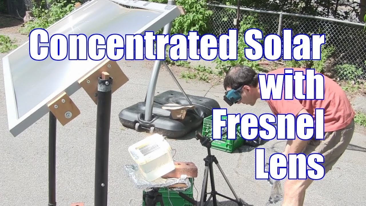
PMMA Fresnel Lens
A flat acrylic panel with thousands of concentric micro-prisms that bend light to a single focal point.
Solar Evaporation System
Concentrated solar energy drives rapid evaporation — producing distilled water with TDS as low as 37 ppm.
Lens Dimensions
Up to 1 600 mm
Custom PMMA Fresnel lenses can be manufactured up to 1.6 m per side. Modular tiling enables single-array footprints of 10 000+ m².
Thickness
2 – 12 mm
Thin-film variants (2–3 mm) for lightweight deployment; rigid plates (8–12 mm) for high-temperature focal stages.
Light Transmittance
92 – 95 %
Optical-grade PMMA captures the solar spectrum across 380–1 100 nm. UV-stabilised grades retain 90 % transmittance after 25 yrs.
Refractive Index
n = 1.49
Constant across visible wavelengths — enables sharply collimated focal points and predictable focal lengths.
F-number
f / 0.5 – 1.2
Ultra-fast optics. Shorter focal ratios mean steeper grooves and higher concentration densities at the focal plane.
Focal Temperature
> 1 500 °C
A 1 m² lens at 1 000× concentration delivers ≈ 9 MJ/s peak — enough to melt steel, vaporise water in ≤0.2 s.
Concentration Ratio
Up to 3 000×
Point-focus configurations reach 3 000 suns; line-focus arrays (chosen here) sit at 200–1 000× for sustained evaporation.
Groove Pitch
0.2 – 1.0 mm
Sawtooth micro-prism pitch tuned per application: fine pitch for image quality, coarse pitch for solar concentration.
Density
1.19 g/cm³
50 % lighter than glass — enables low-profile sun-tracking mounts and floating-pontoon installations directly on the Nile.
Operating Range
–40 °C → +90 °C
Field-grade PMMA stays dimensionally stable across Saharan day-night swings; titanate UV stabilisers extend life to 25+ yrs.
Material
PMMA Acrylic
Polymethyl methacrylate — mass-produced through extrusion, casting or precision injection. Recyclable, food-grade, biocompatible.
Production Cost
≈ $50 – $200 / m²
Industrial-grade Fresnel arrays at scale. Comparable to flat-panel TV optics. ROI < 4 yrs at Egyptian solar irradiance.
Giant flat-panel Fresnel lens arrays — modeled after TV-screen technology — are mounted on steel frameworks spanning the polluted Nile sections. Each panel is a thin PMMA sheet with thousands of concentric micro-prisms etched into its surface.
Computer-controlled sun-tracking pivots keep the lens arrays perpendicular to incoming sunlight throughout the day. The Fresnel prisms bend and focus solar rays to a linear focal zone directly above the water surface.
At the focal zone, concentrated solar energy (up to 1,000× ambient) superheats the water surface to >100 °C, producing rapid evaporation. Pollutants, heavy metals and pathogens remain behind in the residual sludge.
Rising steam is channeled through enclosed aluminum conduit tunnels into condensation chambers cooled by ambient shade and underground thermal mass. Pure distilled water is collected — TDS as low as 37 ppm, well within WHO standards.
Condensed clean water flows by gravity into adjacent stone-lined recovery basins, where it becomes the habitat for fish farming — closing the loop of purification into productive aquaculture.
Flat PMMA sheets are injection-molded at scale — the same factories that produce TV screens can manufacture Fresnel panels.
Purification relies entirely on solar thermal energy — no chlorine, membranes, or chemical reagents needed.
Egypt receives 3,000–3,500 hours of sunshine per year — one of the highest solar irradiation rates on Earth.
PMMA lenses weigh half as much as glass equivalents, reducing structural support costs and enabling rapid installation.
Fresnel lens specifications referenced from industrial PMMA solar concentrators (thin-film type, optical grade).
Research: Frontiers in Energy Research, NASA NTRS, MDPI Energies & Sustainability.
The same superabsorbent polymer found inside a Pampers® diaper can save the Nile's banks. Mixed into the soil, these tiny gel crystals absorb hundreds of times their weight in water — creating a permanent moisture reservoir that roots latch onto, stabilizing the riverbank and fueling a corridor of life.
SAP Hydrogel Crystals
Each bead absorbs 300–500× its weight — a single gram holds half a litre of water.
Stabilized Riverbank
Deep root networks, sustained by hydrogel moisture, anchor the bank against floods and erosion.
Absorption
300–500×
its own weight in water
Soil Retention Boost
Up to 95%
in sandy & arid soils
Degradation Rate
10–15%
per year — biodegradable
Root Suction
1.6–1.7 MPa
exceeds gel retention (1.3–1.4 MPa)
SAP hydrogel beads are mixed into the top soil layer along the Nile's banks. Roots grow through them, drawing water on demand via capillary suction.
Superabsorbent polymer granules (sodium/potassium polyacrylate — the same compound found in Pampers® diapers) are hydrated to form translucent gel beads, each capable of holding 300–500 times its weight in water.
The hydrated gel is blended into the top 30–60 cm of Nile riverbank soil at precise concentrations. The beads act as millions of micro-reservoirs distributed throughout the root zone.
Native Nile vegetation — papyrus, acacia, tamarisk — is planted into the gel-amended soil. Roots naturally draw moisture from the gel beads via capillary suction (roots pull at 1.6 MPa, exceeding the gel's 1.3 MPa hold).
As roots expand through the gel-reinforced matrix, they anchor the bank against erosion. The gel continuously cycles: absorbing floodwater, releasing it during dry spells — creating a self-regulating moisture buffer.
Each gram of SAP gel holds up to 500 ml of water, dramatically reducing irrigation needs and preventing the banks from drying and cracking.
The gel binds loose soil particles into stable aggregates, reducing surface runoff by up to 70% and preventing the Nile from consuming its own banks.
Agricultural-grade SAP degrades at 10–15% per year, breaking down into water, CO₂ and potassium — nutrients that feed the very soil they protected.
During Nile floods, the gel absorbs excess water like a sponge; during drought, it releases it slowly — smoothing the deadly feast-or-famine water cycle.
SAP specifications referenced from agricultural polymer research (Frontiers in Energy, MDPI Gels, SoCo Polymer). Hydrogel technology is the same sodium polyacrylate used in commercial diapers (Pampers®, Huggies®), redeployed for environmental restoration.
How long would it take to evaporate the Nile? We answer with first-principles physics — the latent heat of vaporization, Egyptian solar irradiance, and the optical efficiency of thin-film Fresnel lenses. The numbers reveal both the audacity and the realism of this concept.
Section 1 · Reference Values
Water density
1.000 × 10³
At 25 °C, atmospheric pressure
Specific heat of water
4.186 × 10³
Energy to raise 1 kg by 1 K
Latent heat of vaporization
2.257 × 10⁶
At 100 °C, 1 atm
Solar irradiance (Egypt)
2.500 × 10³
Annual average, Aswan / Luxor latitude
Fresnel collector efficiency
0.92
PMMA thin-film optical transmittance
Nile annual discharge (Aswan)
84.0
≈ 2 830 m³/s mean flow
Section 2 · The Mathematics
Where m is mass of water (kg), ΔT is temperature rise (K) from ambient (25 °C) to boiling (100 °C), and Lᵥ is latent heat of vaporization. The sensible heat term (cₚ · ΔT) accounts for heating; the latent term (Lᵥ) for phase change.
Substituting numerical values for water heated from 25 °C to vapor at 100 °C. Approximately 2.57 MJ are required per kg — nearly 88 % of which goes into the phase change alone.
Where Ĥ is solar irradiance (W/m²), η the optical/thermal efficiency of the Fresnel array, A the lens surface area (m²), and t the operating time (s). Concentration changes intensity, not total energy.
Solving Equations (1) and (3) for time. Doubling the surface halves the evaporation time. The latitude of Aswan (24 °N) yields one of the highest annual irradiance values on Earth.
With Ĥ = 2 500 kWh/m²/yr = 9.00×10⁹ J/m²/yr, η = 0.92 and q = 2.571×10⁶ J/kg: every square metre of Fresnel array evaporates ≈ 3 220 L of water per year — 3–4× the natural evaporation rate of an open pond at the same latitude.
Section 3 · Numerical Scenarios
| Quantity | Pilot | Regional | National | Maximal |
|---|---|---|---|---|
| Lens area A | 1 km² | 100 km² | 1 000 km² | 28 000 km² |
| Annual evaporated volume | 3.22 × 10⁶ m³ · yr⁻¹ | 0.322 km³ · yr⁻¹ | 3.22 km³ · yr⁻¹ | 90.2 km³ · yr⁻¹ |
| Fraction of Nile discharge | 0.0038 % | 0.38 % | 3.83 % | 107 % |
| Years to cycle full Nile (84 km³) | ≈ 26 100 yr | ≈ 261 yr | ≈ 26.1 yr | ≈ 0.93 yr |
| Daily energy delivered | 2.27 × 10¹³ J | 2.27 × 10¹⁵ J | 2.27 × 10¹⁶ J | 6.35 × 10¹⁷ J |
| Equivalent to (per day) | 6.3 GWh | 630 GWh | 6.3 TWh | 176 TWh |
Notation: 1 km³ = 10⁹ m³ = 10¹² L. All values assume Ĥ = 2 500 kWh/m²/yr, η = 0.92, q = 2.571 MJ/kg. “Maximal” represents the asymptotic limit equal to the Nile’s mean annual discharge.
Section 4 · Time Function t(A)
The relationship is hyperbolic: time scales inversely with area. From Equations (4) and (5):
Reading the chart: a pilot installation of 1 km² would need 26 millennia to evaporate the Nile’s annual flow once — obviously absurd. With 1 000 km² (one third of Singapore’s territory), the cycle drops to 26 years; with 10 000 km² of Fresnel-array desert real estate, less than three years.
Section 5 · Physical Interpretation
The total energy budget is 2.16×10²¹ J/yr — ≈ 36 % of global primary energy. Forced evaporation is meant for selective purification, not bulk drying.
~1 000–1 500 km² of Fresnel array along the riverbanks evaporates 3–5 km³ yr⁻¹ — distilling enough water to irrigate 600 000 ha of new farmland.
Every m³ of pure distillate leaves ≈ 1.3 kg of salts + minerals + heavy metals — separable feedstock for halite, gypsum and trace metals (Cu, Pb, Cd) recovery.
At 24 °N the direct normal irradiance reaches 2 800–3 100 kWh/m²/yr — 25–40 % more than European Mediterranean coasts and 60 % higher than the global mean.
Reference values: latent heat & specific heat — NIST WebBook; Nile discharge — Conway & Hulme (1996), Climatic Change 32(3); Egyptian solar resource — NASA POWER & Solargis (2023). All arithmetic uses SI units and is verifiable.
Forced evaporation is not destruction — it is acceleration of the hydrologic cycle. Every m³ of vapour that rises from a Fresnel array seeds clouds that drift inland, fall as rain, and trigger a vegetation feedback loop powerful enough to re-green the Sahara. The water is never lost. It only changes hands.
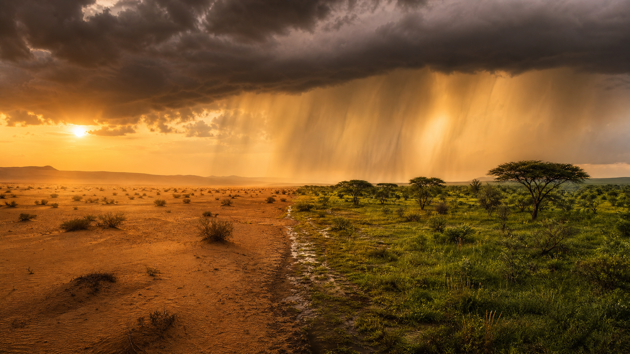
Half desert. Half savanna. Born from the same drop.
A symbolic landscape — the same Saharan ground that lies fallow today can bloom again under engineered rainfall.
Section 1 · Hydrologic Parameters
Cloud Yield per m³ Vapor
1.7 × 10⁶ m³
A single cubic metre of evaporated water expands 1 700 000× as it cools into cumulus cloud volume.
Prevailing Wind Speed
4 – 8 m/s
Northern trade winds (Etesians) carry moisture south & southwest — into the Sahara’s heart.
Land Recycling Ratio
30 – 40 %
In vegetated regions, that share of rainfall is local evapotranspiration recycled into precipitation.
Target Rainfall (Green Corridor)
+ 400 mm/yr
Lifting Egypt’s 18–200 mm baseline toward 400–600 mm — the threshold for stable savanna.
Greenable Footprint
100 000 km²
A Sahel-buffer corridor along the Sahara’s southern edge, recoverable within a generation.
Albedo Shift
0.45 → 0.20
Bare sand reflects 45 % of sunlight; vegetated savanna only 20 % — locking in heat & moisture.
Section 2 · The Cycle
Fresnel arrays vaporise polluted Nile water at the rate of 3.22 m³ per m² per year. Each km² of array lifts ≈ 3.2 × 10⁶ m³ of clean vapour per year.
Hot vapour rises buoyantly to the lifting condensation level (LCL) at 800–2 000 m, condensing into cumulus humilis and stratocumulus cloud sheets.
Etesian winds and southerly monsoonal currents drift the seeded clouds 100–400 km inland, distributing moisture far beyond the original riverbank.
Cloud droplets coalesce (Bergeron-Findeisen process). Rainfall reaches arid soil already prepared with hydrogel banks and root-zone water reservoirs.
Pioneer grasses and acacia roots stabilise the soil, increase evapotranspiration, lower albedo and trigger a positive feedback loop that amplifies regional rainfall.
Nile water never disappears. It travels: river → vapour → cloud → rain → soil → plant → evapotranspiration → cloud. Each loop greens a wider belt.
Section 3 · Precedent
From 11 700 to 5 500 BCE, the Sahara was a green savanna. Pollen cores from Lake Yoa (Chad) reveal continuous vegetation cover. Vegetation–precipitation feedback sustained the climate.
Hippopotami, giraffes, antelope and dancing humans — painted in today’s Algerian desert. Direct visual evidence of a verdant past sustained by the same physics we now harness.
China’s “Green Wall” (Loess Plateau) lifted regional rainfall by 12 % through tree planting. Sahel “Great Green Wall” targets 100 million ha of restored land by 2030.
Modelled by Kröpelin & deMenocal (Science 2008): a 10 % vegetation cover increase shifts the monsoon belt 4–6° north — restoring rainfall over today’s drylands.
References: Kröpelin et al. Science (2008); deMenocal & Tierney Quaternary Science Reviews (2012); Sahel « Great Green Wall » (UNCCD 2023); Loess Plateau rehabilitation report (World Bank 2007).
From the granite cataracts of Aswan to the Mediterranean shores of Alexandria, 1 120 kilometres of civilisation cling to the riverbanks — a ribbon of cities, temples, factories, highways and 7 000 years of continuous habitation.
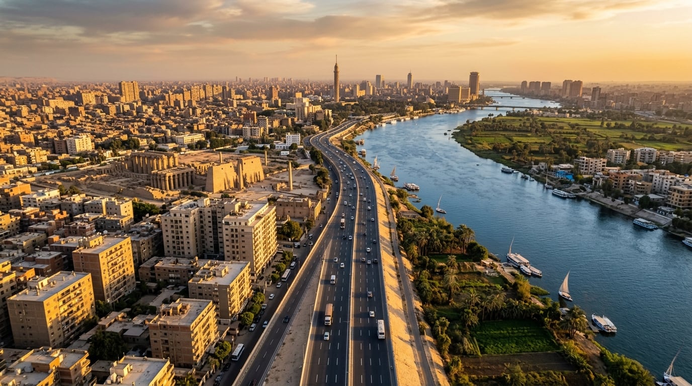
The Nile Valley Highway — linking Africa's oldest urban corridor
1 120 km
Total Length
Aswan to Mediterranean coast
34
Cities >100k
Urban centres lining the corridor
47
Bridges
Spanning the Nile from south to north
255 k+
Constructions
Buildings within 2 km of the banks
4 800 km
Road Network
Paved roads in the corridor belt
1 230 km
Rail Lines
Egyptian National Railways along Nile
Over 255 000 structures lie within 2 km of the Nile banks. Here is how they break down by category.
62%
Residential
14%
Industrial
11%
Commercial
5%
Heritage Sites
8%
Infrastructure
Gateway to Upper Egypt
1.6M
Twin-Temple city
0.3M
Temple of Horus
0.15M
World's largest open-air museum
1.3M
Industrial hub of Upper Egypt
0.25M
Textile capital
0.5M
Capital of Upper Egypt
0.5M
Bride of Upper Egypt
0.4M
Rail junction of the Nile
0.3M
Megacity — Mother of the World
22M
Heart of the Delta
0.5M
Pearl of the Mediterranean
5.4M
→ Mediterranean Sea
End of the corridor — where the Nile meets the sea
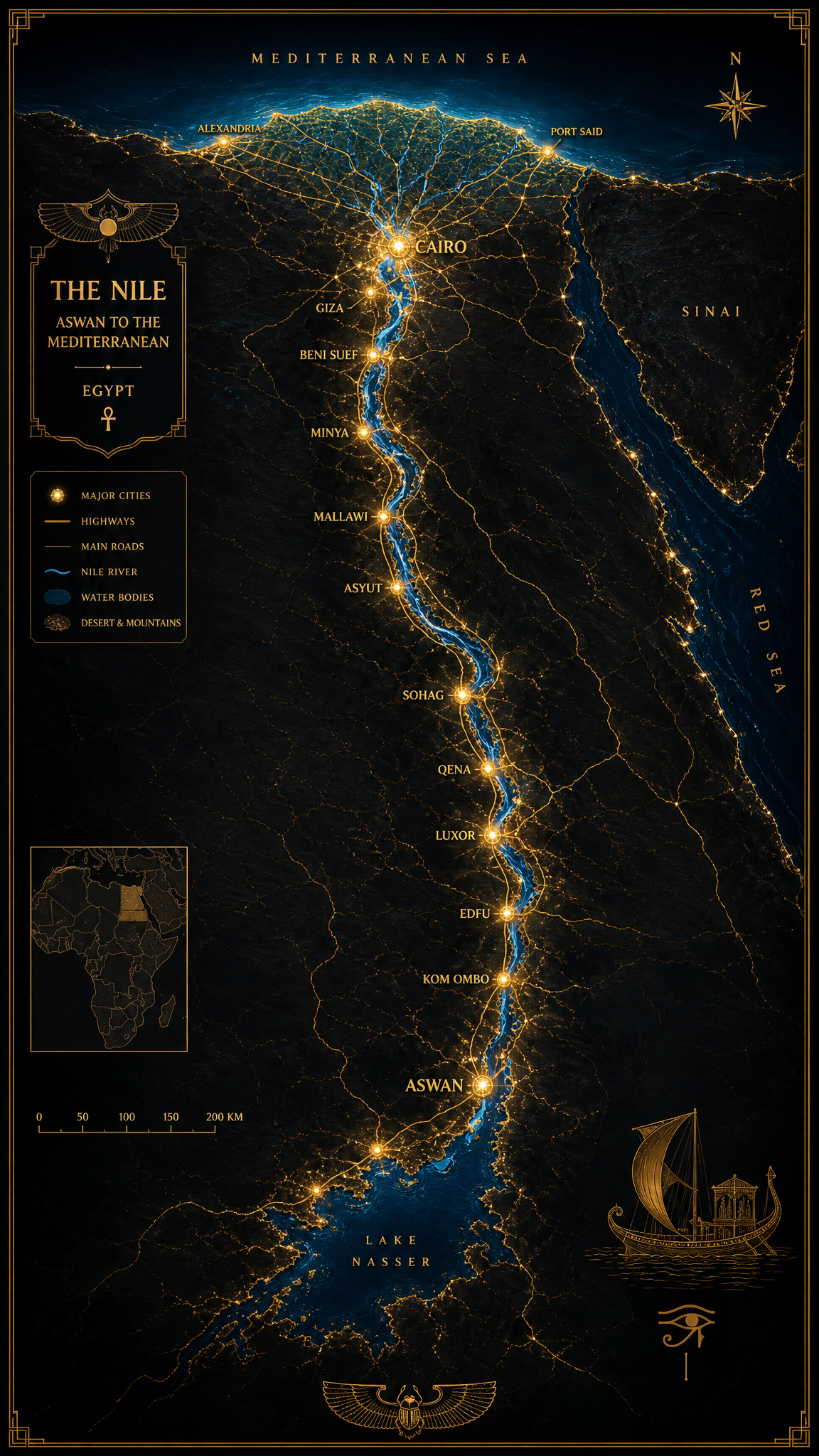
12 cities · 1 120 km · 1 highway
Every kilometre of the Nile sustains an average of 228 buildings, 4.3 km of road and 1.1 km of rail. The forced-evaporation programme will gradually expose the riverbed, enabling the construction of a new linear megacity — a 1 120 km urban spine from Aswan to the sea, built on reclaimed land with modern infrastructure, solar power grids, and green belts fed by the Rain Engine's engineered precipitation.
For seven millennia, the river has swallowed gifts of empires — royal jewelry, ceremonial vessels, lost cargo and pharaonic statues. As the Nile is drained and cleansed, an unprecedented archaeological harvest awaits.
Estimated total value
$60B+
A speculative but grounded estimate of pharaonic, Greco-Roman, Islamic and colonial-era artifacts lying beneath the riverbed and delta. Scholars believe hundreds of thousands of objects remain undiscovered.
Sunken monumental sculptures, obelisks fragments, ceremonial stelae.
Royal jewelry, ceremonial vessels, gilded amulets lost in floods and shipwrecks.
Alexandrian cargo, coins, mosaics and statues from sunken ports.
Islamic-era ceramics, spices in sealed amphorae, navigation instruments.
Wooden royal boats, granite blocks, and tribute shipments.
Sealed jars, ostraca and household objects preserved by silt.
Excess algae — the green plague of polluted waters — is harvested in vast quantities, then carbonized into charcoal. Once the Nile bed is cleansed, a controlled release of seawater forms a mineral-rich salty layer that locks the riverbed in natural preservation.

Phase 1 — Harvest
Floating algae rafts are mechanically skimmed and dewatered.

Phase 2 — Carbonize
Pyrolysis kilns turn biomass into clean-burning charcoal and biochar.
Skim floating algae mats from the river surface using mechanical rakes and rafts.
Pyrolyze dewatered algae into charcoal — a stable fuel and powerful soil amendment.
With algae and pollutants removed, the riverbed is scoured down to its mineral floor.
Controlled seawater release deposits a salty bottom layer — a natural preservative foundation.
After the algae harvest, controlled seawater intrusion crystallizes a mineral base that prevents new pollutants from leaching upward — a natural seal beneath a reborn river.

